CGG Satellite Mapping Completes Barents Sea Seeps Study for Norwegian Petroleum Directorate
Paris, France | Jan 12, 2021
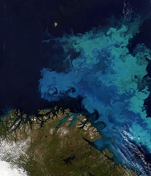
CGG’s Satellite Mapping group recently completed an innovative high-resolution hydrocarbon seeps study commissioned by the Norwegian Petroleum Directorate (NPD). The aim of the study was to increase petroleum system knowledge across a relatively data-poor area of the northern Barents Sea.
CGG Satellite Mapping has over twenty-five years of experience in the detection and characterization of offshore seeps and slicks based on its expert remote sensing processing and analysis of Synthetic Aperture Radar (SAR) satellite imagery. To meet the requirements of the study, CGG Satellite Mapping custom-tasked next-generation SAR satellites to acquire a large collection of high-spatial-resolution SAR imagery at a high revisit frequency. Subsequent advanced processing and analysis by its experts identified the presence of small-scale naturally occurring seepage slick features, unlocking valuable subsurface intelligence.

Satellite image of part of the Barents Sea (courtesy of CGG; MODIS data courtesy of NASA).
About CGG
CGG (www.cgg.com) is a global geoscience technology leader. Employing around 3,700 people worldwide, CGG provides a comprehensive range of data, products, services and solutions that support our clients to more efficiently and responsibly solve complex natural resource, environmental and infrastructure challenges. CGG is listed on the Euronext Paris SA (ISIN: 0013181864).


