


Algoa 3D Marine Seismic Survey Information
Following the public consultation on the proposed 3D marine seismic survey in the offshore Algoa Bay area, held during the Environmental Management Plan preparation phase, the Reconnaissance Permit application may be delayed. Given the limited operational time-window for work in the area of the proposed survey, it may be necessary to postpone operations until the 2023 Austral summer survey window period.
This page provides general background and more detailed information about the survey:
1. Who is CGG?
2. What is ‘multi-client data’?
3. What kind of activities are planned to be conducted during the offshore Algoa Bay area?
4. Why is new data needed in this area?
5. How are seismic surveys authorized?
6. Do CGG activities impact the environment?
7. Is there a potential impact on fish?
8. What are the impacts of seismic operations on fisheries?
1. Who is CGG?
CGG is a global leader in cutting-edge geoscience. We have a strong focus on innovation and a commitment to delivering the best sustainable solutions to our clients' energy challenges. We provide our with clients a unique range of technologies, services and equipment designed to acquire extremely precise data and images of the Earth's subsurface. We also provide state-of-the-art software and services for analyzing that data and developing a deeper understanding of the subsurface for exploration, production and optimization of hydrocarbon reservoirs and carbon and energy storage.
2. What is ‘multi-client data’?
Geophysical surveys are acquired either on a multi-client or proprietary basis. A proprietary survey is typically acquired by a single company using a geophysical contractor limited to its area of interest. Multi-client data is acquired by a geophysical company, covers a larger area of interest, and the data is licensed to clients on a non-exclusive basis.
The environmental advantage of the multi-client approach is that a single multi-client survey will fulfill the exploration requirements of a larger number of companies, rather than each of these companies acquiring separate proprietary surveys.
3. What kind of activities are planned to be conducted in the offshore Algoa Bay area?
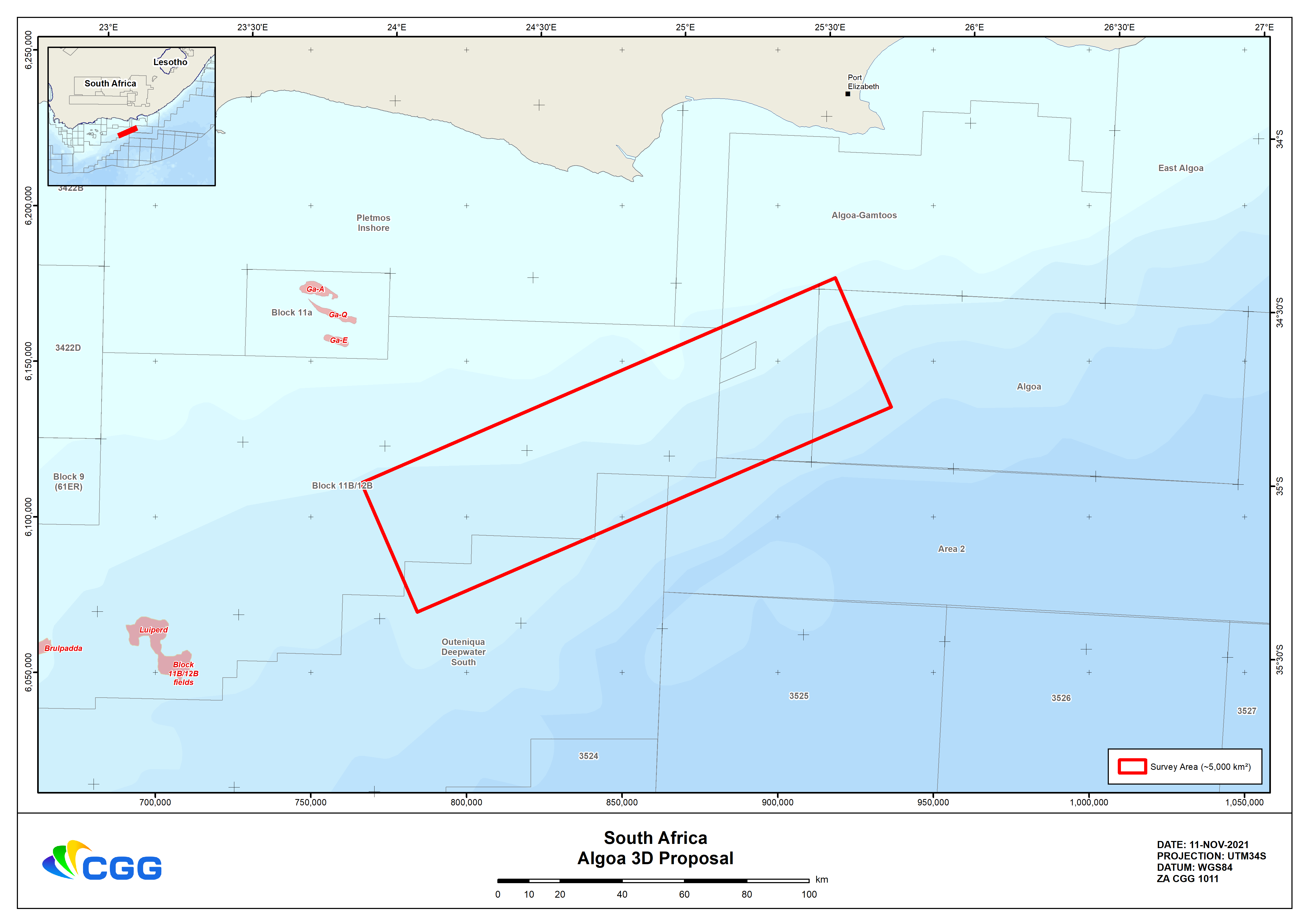
The proposed Algoa 3D marine seismic survey aims to explore the area to evaluate its potential natural resources. The survey vessel will operate over 5,000 km2, although the area actively surveyed will be smaller than this.
The survey vessel will be operating in South African waters ranging from around 300 m to 4,000 m deep.
The primary purpose of seismic exploration is to render the most accurate possible graphic representation of the Earth's subsurface geologic structure. This involves the transmission of controlled acoustic energy into the Earth and recording the acoustic energy reflected from geologic boundaries in the subsurface.
The images produced allow the evaluation of the area for its potential to yield natural resources. Seismic surveys are the primary tool used in oil & gas exploration and are used routinely throughout the world and around Africa. Many 2D and 3D surveys have taken place offshore South Africa for several decades alongside other activities, such as petroleum production and commercial fishing.
CGG will carry out the Algoa 3D marine seismic survey through a third-party acquisition partner.
For more information on the role of seismic surveys, please follow this link
4. Why is new data needed in this area?
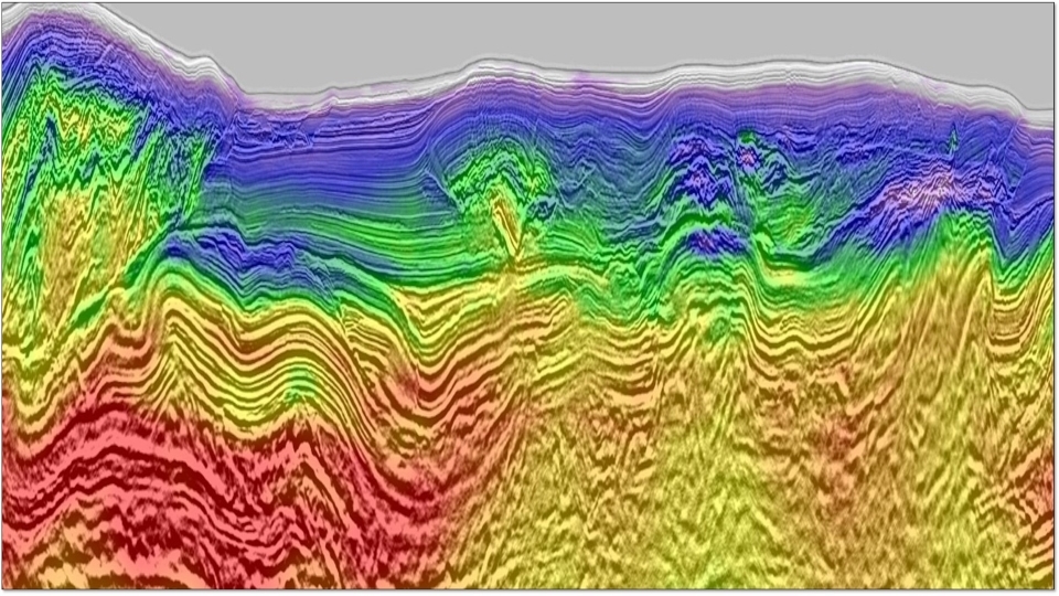
The Algoa-Gamtoos Basins were underexplored until the successful 2019 Brulpadda-1 and 2020 Luiperd-1X discoveries made in Block 11B/12B. CGG's survey area is located on trend from these discoveries to the east. Historically, the wells in Algoa-Gamtoos Basins were primarily drilled using decades-old marine seismic data. Our vessel contractor's modern marine seismic acquisition solutions combined with state-of-the-art processing technology will identify and de-risk exploration targets in these basins.
The examples below illustrate the relative improvement in seismic imaging technology over time, and indicate the expected uplift from new data:

New acquisition is required to better image rocks beneath the coals, which might contain new oil and gas deposits.
5. How are seismic surveys authorized?
In 2021 CGG initiated an Environmental Management Program (EMPr) process for a proposed seismic survey off the Southeast Coast of South Africa.
Due to the changes in the environmental legislation in South Africa, which indicated that an application for Environmental Authorization (EA) was required for exploration activities to be undertaken under a Reconnaissance Permit, rather than the previously stipulated EMPr process, CGG suspended its application process.
The project was re-initiated by CGG in 2023 with the resubmission of a Reconnaissance Permit application and an Application for Environmental Authorization in terms of the National Environmental Management Act, 1998 (No. 107 of 1998) and the related Environmental Impact Assessment Regulations, 2014 (as amended). This required the undertaking of a Basic Assessment and related public participation process. Following the assessment process and submission of final documentation in July 2023, CGG was granted an Environmental Authorization in November 2023 to carry out this survey. This process of obtaining the Authorization has not only involved the Government Competent Authorities but also relevant Stakeholders and Interested parties within the South African public. CGG has adhered to all stipulated South African regulations in obtaining all authorizations to undertake its activities. CGG abides by the strictest environmental standards in undertaking its activities globally.
6. Do CGG activities impact the environment?
CGG's marine seismic surveys are typically short-term events that can provide indirect environmental benefits during the hydrocarbon exploration cycle. This is generally achieved by reducing the number of exploration and/or appraisal wells required to be drilled and reducing the number of times a seismic vessel may be required to shoot smaller proprietary surveys in the area.
CGG applies risk-based mitigation measures that have been tailored to the local environment as a result of the EMP approval process. These include specific obligations protecting marine life in line with national requirements and international laws and regulations.
An example of these environmental obligations is the "soft start" approach to commencing each surveying phase, whereby the source's output is gradually increased over a 20 minute period to avoid startling any nearby marine life. Other obligations include contracting independent Marine Mammal Observers (MMOs) and Passive Acoustic Monitoring Operators (PAMO) to provide 24hr dedicated marine mammal detection solutions onboard the vessel. Should a marine mammal approach too close to the ship during the operation, surveying would pause until the mammal moves away.
More information on the impact of seismic surveys on marine life is at this link.
7. Is there a potential impact on fish?
Recent research conducted by the Australian Institute of Marine Science (AIMS), published in July 2021, found that marine seismic surveys did not impact the abundance and behavior of nearby fish stocks. This comprehensive and large-scale study measured both the short-term and long-term effects of seismic airguns, concluding that there were no changes in key behaviors after the fish were exposed to seismic pulses. Dr. Miles Parsons, AIMS acoustic scientist and co-author, said: "What makes this research unique and robust is we used an actual seismic vessel in a real ocean environment and some of the most advanced technologies to track and measure possible impacts." He further adds that the results from such a significant study will "provide valuable knowledge on potential impacts in other environments, not just in Australia but internationally."
The results can be accessed at this link
The EMP will assess and discuss potential impacts, including those on local fish species.
8. What are the impacts of seismic operations on fisheries?
Our seismic surveys are designed, planned, and executed to prevent potential usage conflicts with other sea users. Early stakeholder engagement and local consultations aim to limit interference to the lowest levels possible. Ongoing communications with all interested parties are maintained throughout the survey.
CGG will also engage a locally sourced Fisheries Liaison Officer to sail with the vessel to interact offshore with the local fishing community.
The seismic vessel sails slowly (about 4.5 knots) and has limited maneuverability due to the length of the towed cables. One or more support vessels will escort the seismic vessel during operations to alert other ships in the area to the presence of the survey vessel.
The proposed program map shows the approximate vessel and survey footprint (red rectangle) within the proposed acquisition area.